
Frome topographic map
Click on the map to display elevation.
About this map
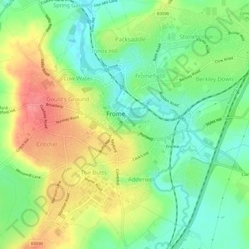
Name: Frome topographic map, elevation, terrain.
Location: Frome, Somerset, England, United Kingdom (51.21375 -2.34214 51.24537 -2.29095)
Average elevation: 90 m
Minimum elevation: 58 m
Maximum elevation: 132 m
Other topographic maps
Click on a map to view its topography, its elevation and its terrain.
Thorne St Margaret
United Kingdom > England > Somerset > Somerset West and Taunton > Holywell Lake
Average elevation: 94 m