
Thank you for supporting this site ❤️
Make a donation
Make a donation
Elk County topographic map
Click on the map to display elevation.
Thank you for supporting this site ❤️
Make a donation
Make a donation
About this map
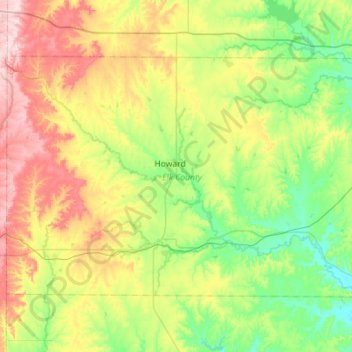
Name: Elk County topographic map, elevation, terrain.
Location: Elk County, Kansas, United States (37.29962 -96.52670 37.60702 -95.96100)
Average elevation: 343 m
Minimum elevation: 256 m
Maximum elevation: 508 m
Thank you for supporting this site ❤️
Make a donation
Make a donation
Other topographic maps
Click on a map to view its topography, its elevation and its terrain.