
Thank you for supporting this site ❤️
Make a donation
Make a donation
Long Island topographic map
Click on the map to display elevation.
Thank you for supporting this site ❤️
Make a donation
Make a donation
About this map
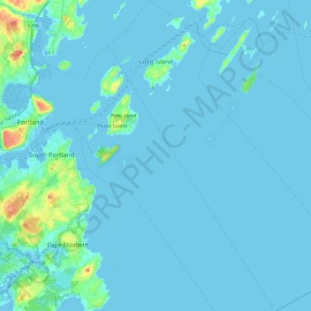
Name: Long Island topographic map, elevation, terrain.
Location: Long Island, Cumberland County, Maine, 04050, United States (43.55734 -70.19919 43.72405 -70.01672)
Average elevation: 4 m
Minimum elevation: -2 m
Maximum elevation: 54 m
Thank you for supporting this site ❤️
Make a donation
Make a donation
Other topographic maps
Click on a map to view its topography, its elevation and its terrain.
Cliff Island
United States > Maine > Cumberland County > Portland > Cliff Island
Average elevation: 1 m
Thank you for supporting this site ❤️
Make a donation
Make a donation
Thank you for supporting this site ❤️
Make a donation
Make a donation