
Thank you for supporting this site ❤️
Make a donation
Make a donation
Bad Tabarz topographic map
Click on the map to display elevation.
Thank you for supporting this site ❤️
Make a donation
Make a donation
About this map
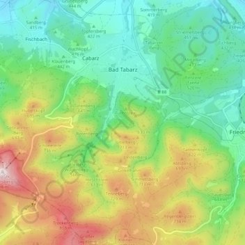
Name: Bad Tabarz topographic map, elevation, terrain.
Location: Bad Tabarz, Landkreis Gotha, Thuringia, 99891, Germany (50.83274 10.46355 50.89424 10.54133)
Average elevation: 538 m
Minimum elevation: 333 m
Maximum elevation: 908 m
Thank you for supporting this site ❤️
Make a donation
Make a donation
Other topographic maps
Click on a map to view its topography, its elevation and its terrain.