
Egazelai topographic map
Interactive map
Click on the map to display elevation.
About this map
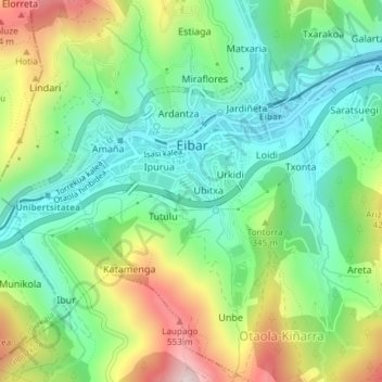
Name: Egazelai topographic map, elevation, terrain.
Average elevation: 278 m
Minimum elevation: 106 m
Maximum elevation: 604 m
Other topographic maps
Click on a map to view its topography, its elevation and its terrain.
Trango
España > País Vasco > Bajo Deba > Éibar
Trango, Kortalarrañeta, Mandiola, Éibar, Bajo Deba, Guipúzcoa, País Vasco, 20600, España
Average elevation: 469 m
Éibar
España > País Vasco > Bajo Deba > Éibar
Éibar, Bajo Deba, Guipúzcoa, País Vasco, 20600, España
Average elevation: 376 m
Arrate
España > País Vasco > Bajo Deba > Éibar
Arrate, Éibar, Bajo Deba, Guipúzcoa, País Vasco, 20600, España
Average elevation: 332 m