
Kokernag topographic map
Interactive map
Click on the map to display elevation.
About this map
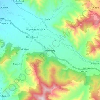
Name: Kokernag topographic map, elevation, terrain.
Average elevation: 2,084 m
Minimum elevation: 1,785 m
Maximum elevation: 2,729 m
Other topographic maps
Click on a map to view its topography, its elevation and its terrain.
Kriti
India > Jammu and Kashmir > Kokernag Tehsil
Kriti, Kokernag Tehsil, Anantnag District, Jammu and Kashmir, India
Average elevation: 2,288 m