Chelmsford topographic map
Interactive map
Click on the map to display elevation.
About this map
![Chelmsford topographic map, elevation, terrain](/pub/maps/relation/cf3q/kx7t6/thumbnail.jpg)
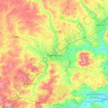
Name: Chelmsford topographic map, elevation, terrain.
Location: Chelmsford, Essex, England, United Kingdom (51.61662 0.33216 51.85748 0.64898)
Average elevation: 54 m
Minimum elevation: -1 m
Maximum elevation: 113 m
Other topographic maps
Click on a map to view its topography, its elevation and its terrain.
![Ramsden Heath topographic map, elevation, terrain](/pub/maps/node/tqm2/3kghd18/icon.jpg)
Ramsden Heath
United Kingdom > England > Essex > Chelmsford
Ramsden Heath, Chelmsford, Essex, England, CM11 1HX, United Kingdom
Average elevation: 58 m
![Great Chesterford topographic map, elevation, terrain](/pub/maps/relation/9rt6/6njp4s/icon.jpg)
Great Chesterford
United Kingdom > England > Essex > Uttlesford
Great Chesterford, Uttlesford, Essex, England, United Kingdom
Average elevation: 58 m