
Stumpf topographic map
Interactive map
Click on the map to display elevation.
About this map
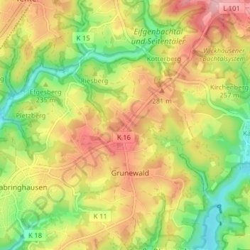
Name: Stumpf topographic map, elevation, terrain.
Average elevation: 245 m
Minimum elevation: 172 m
Maximum elevation: 318 m
Other topographic maps
Click on a map to view its topography, its elevation and its terrain.
Rölscheid
Deutschland > Nordrhein-Westfalen > Rheinisch-Bergischer Kreis > Wermelskirchen > Grunewald > Rölscheid
Rölscheid, Grunewald, Wermelskirchen, Rheinisch-Bergischer Kreis, Nordrhein-Westfalen, 42929, Deutschland
Average elevation: 231 m