
Delitzsch topographic map
Interactive map
Click on the map to display elevation.
About this map
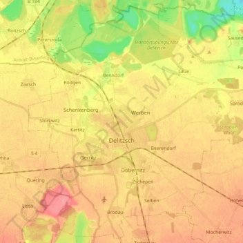
Name: Delitzsch topographic map, elevation, terrain.
Location: Delitzsch, Nordsachsen, Saxony, 04509, Germany (51.48097 12.27433 51.58696 12.45214)
Average elevation: 95 m
Minimum elevation: 53 m
Maximum elevation: 124 m
Delitzsch is located in the northwestern part of Nordsachsen in Saxony, at an altitude of 94 meters above sea level. Due to its location on the border with Saxony-Anhalt, Delitzsch is the northernmost town in Saxony. It is situated on the north heath and recreation area Goitzsche which extends across the Saxony-Saxony-Anhalt border to Bitterfeld-Wolfen. To the east is the spa town of Bad Düben, which is the starting point for the Düben Heath.
Other topographic maps
Click on a map to view its topography, its elevation and its terrain.
Eilenburg
Germany > Saxony > Nordsachsen
Eilenburg, Nordsachsen, Saxony, 04838, Germany
Average elevation: 114 m