
Ko Rok Noi topographic map
Interactive map
Click on the map to display elevation.
About this map
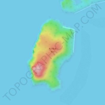
Name: Ko Rok Noi topographic map, elevation, terrain.
Location: Ko Rok Noi, Provinz Krabi, Thailand (7.19720 99.05266 7.21631 99.06538)
Average elevation: 21 m
Minimum elevation: 0 m
Maximum elevation: 204 m
Other topographic maps
Click on a map to view its topography, its elevation and its terrain.
หมู่เกาะพีพี
Thailand > Provinz Krabi > หาดแหลมทอง
หมู่เกาะพีพี, หาดแหลมทอง, Provinz Krabi, Thailand
Average elevation: 2 m