
Make a donation
Nagpur topographic map
Click on the map to display elevation.
Make a donation
Nagpur
Nagpur is located at the exact centre of the Indian subcontinent, close to the geometric centre of the quadrilateral connecting the four major metros of India, viz. Chennai, Mumbai, New Delhi and Kolkata. The city has the Zero Mile Stone locating the geographical centre of India, which was used by the British to measure all distances within the Indian subcontinent. The city lies on the Deccan plateau of the Indian subcontinent and has a mean altitude of 310.5 meters above sea level. The underlying rock strata are covered with alluvial deposits resulting from the flood plain of the Kanhan River. In some places, these give rise to granular, sandy soil. In low-lying areas, which are poorly drained, the soil is alluvial clay with poor permeability characteristics. In the eastern part of the city, crystalline metamorphic rocks such as gneiss, schist and granites are found, while in the northern part, yellowish sandstones and clays of the lower Gondwana formations are found. Nagpur city is dotted with natural and artificial lakes. The largest lake is Ambazari Lake. Other natural lakes include Gorewada Lake and Telankhedi lake. Sonegaon and Gandhisagar Lakes are artificial, created by the city's historical rulers. Nag river, Pilli Nadi, and nallas form the natural drainage pattern for the city. Nagpur is known for its greenery and was adjudged the cleanest and second greenest in India after Chandigarh in 2010.
Make a donation
About this map
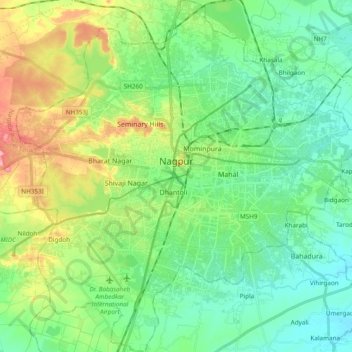
Name: Nagpur topographic map, elevation, terrain.
Location: Nagpur, Maharashtra, India (21.05297 78.99522 21.23100 79.17885)
Average elevation: 309 m
Minimum elevation: 274 m
Maximum elevation: 389 m
Make a donation
Other topographic maps
Click on a map to view its topography, its elevation and its terrain.
Maharashtra
Maharashtra is the third largest state by area in India. The Western Ghats better known as Sahyadri, are a hilly range running parallel to the coast, at an average elevation of 1,200 metres (4,000 ft). Kalsubai, a peak in the Sahyadris, near Nashik city is the highest elevated point in Maharashtra. To the west…
Average elevation: 478 m
Make a donation
Navi Mumbai
India > Maharashtra > Thane > Navi Mumbai
Navi Mumbai (Marathi pronunciation: , also known by its former name New Bombay), is a planned city off the west coast of the Indian state of Maharashtra in Konkan division. The city is divided into two parts, North Navi Mumbai and South Navi Mumbai, for the individual development of Panvel Mega City, which…
Average elevation: 30 m
Solapur
India > Maharashtra > Solapur North
Solapur is located at 17°41′N 75°55′E / 17.68°N 75.92°E / 17.68; 75.92. It has an average elevation of 458 metres (1502 feet). It is bordered by Ahmednagar district on the north; Osmanabad district on the north and northeast.
Average elevation: 469 m
Make a donation
Amravati
India > Maharashtra > Amravati
Amravati is located at 20°56′N 77°45′E / 20.93°N 77.75°E / 20.93; 77.75. It has an average elevation of 343 meters (1125 feet). It lies 156 km (97 mi) west of Nagpur and serves as the administrative centre of Amravati District and of Amravati Division. The city is located near the passes…
Average elevation: 345 m
Talegaon Dabhade
India > Maharashtra > Mawal
Talegaon Dabhade has an altitude of 672 meters from sea level (2200 Ft), and thus enjoys pleasant weather round the year. Situated on the laps of Sahyadri mountain ranges, during monsoon rains, Talegaon Dabhade witnesses heavy rainfall adding to its overall natural beauty. Indrayani River, which originates in…
Average elevation: 616 m
Make a donation
Make a donation
Make a donation
Make a donation
Mumbai
Mumbai lies at the mouth of the Ulhas River on the western coast of India, in the coastal region known as the Konkan. It sits on Salsette Island (Sashti Island), which it partially shares with the Thane district. Mumbai is bounded by the Arabian Sea to the west. Many parts of the city lie just above sea level,…
Average elevation: 13 m
Make a donation
Make a donation
Make a donation
Make a donation
Make a donation
Make a donation
Parbhani
India > Maharashtra > Parbhani
Parbhani is located at 19°16′N 76°47′E / 19.27°N 76.78°E / 19.27; 76.78. It has an average elevation of 347 metres.
Average elevation: 411 m
Make a donation
Alibag
India > Maharashtra > Alibag Taluka
Alibag is located about 120 km south of Mumbai, at 18°38′29″N 72°52′20″E / 18.64139°N 72.87222°E / 18.64139; 72.87222. The average elevation is 0 metres (0 feet).The District Government offices are located along the sea coast road. Alibag is the center place of Raigad District.
Average elevation: 12 m
Mahad
India > Maharashtra > Mahad Taluka
Several disasters like floods and landslides have continuously devastated markets and old houses, specifically classic Konkani-styled architecture, causing great loss of life. This is primarily due to lower elevation of the city compared to surrounding areas and being surrounded by rivers on all sides, making…
Average elevation: 75 m
Make a donation
Make a donation
Make a donation
Make a donation
Make a donation
Make a donation
Lonavala
India > Maharashtra > Mawal
Adjacent to the Lohagad fort lies the visapur fort which is part of the Lohagad-Visapur fortification. Visapur Fort is larger and at a higher elevation than its twin- Lohagad. It was built during 1713-1720 CE by Balaji Vishwanath.
Average elevation: 613 m
Make a donation
Make a donation
Pench (Indira Priyadarsini) National Park/Tiger Reserve
India > Maharashtra > Ramtek Taluka
Average elevation: 485 m
Nashik
India > Maharashtra > Nashik Subdistrict
The city's tropical location and high altitude combine to give it a relatively mild version of a tropical wet and dry climate (Köppen Aw). Temperatures rise slightly in October, but this is followed by the cool season from November to February. The cool season sees warm temperatures of around 28 °C or 82.4…
Average elevation: 631 m
Make a donation
Arvi
India > Maharashtra > Arvi
Arvi is located at 20°35′N 79°08′E / 20.59°N 79.14°E / 20.59; 79.14. It has an average elevation of 328 metres (1075 feet). Arvi is an important centre for the cotton and soybean trade. The closest airport from Arvi is Nagpur Airport situated at 100 kilometres and the closest Railway Station…
Average elevation: 302 m
Make a donation
Make a donation
Make a donation