
Quarten topographic map
Interactive map
Click on the map to display elevation.
About this map
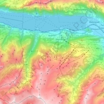
Name: Quarten topographic map, elevation, terrain.
Location: Quarten, Wahlkreis Sarganserland, Saint-Gall, Suisse (47.02592 9.13806 47.14871 9.30368)
Average elevation: 1,283 m
Minimum elevation: 416 m
Maximum elevation: 2,490 m
Other topographic maps
Click on a map to view its topography, its elevation and its terrain.
Tannenboden
Suisse > Saint-Gall > Wahlkreis Sarganserland
Tannenboden, Flums, Wahlkreis Sarganserland, Saint-Gall, 8898, Suisse
Average elevation: 1,102 m
Sargans
Suisse > Saint-Gall > Wahlkreis Sarganserland
Sargans, Wahlkreis Sarganserland, Saint-Gall, 7320, Suisse
Average elevation: 707 m
Mels
Suisse > Saint-Gall > Wahlkreis Sarganserland
Mels, Wahlkreis Sarganserland, Saint-Gall, Suisse
Average elevation: 1,317 m