
Wykagyl topographic map
Interactive map
Click on the map to display elevation.
About this map
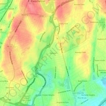
Name: Wykagyl topographic map, elevation, terrain.
Average elevation: 46 m
Minimum elevation: 5 m
Maximum elevation: 80 m
Other topographic maps
Click on a map to view its topography, its elevation and its terrain.
Bonnie Crest
United States > New York > Westchester County > City of New Rochelle
Bonnie Crest, City of New Rochelle, Westchester County, New York, 10804, United States
Average elevation: 58 m
Sedge Island
United States > New York > Westchester County > City of New Rochelle
Sedge Island, City of New Rochelle, Westchester County, New York, 10805, United States
Average elevation: 47 m