
Thank you for supporting this site ❤️
Make a donation
Make a donation
Quibala topographic map
Click on the map to display elevation.
Thank you for supporting this site ❤️
Make a donation
Make a donation
About this map
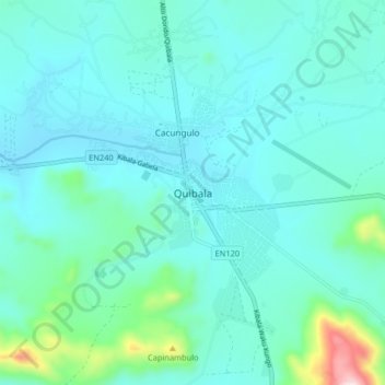
Name: Quibala topographic map, elevation, terrain.
Location: Quibala, Cuanza Sul, Angola (-10.77254 14.94055 -10.69254 15.02055)
Average elevation: 1,324 m
Minimum elevation: 1,245 m
Maximum elevation: 1,801 m
Thank you for supporting this site ❤️
Make a donation
Make a donation
Other topographic maps
Click on a map to view its topography, its elevation and its terrain.