
Thank you for supporting this site ❤️
Make a donation
Make a donation
Plettenberg Bay topographic map
Click on the map to display elevation.
Thank you for supporting this site ❤️
Make a donation
Make a donation
About this map
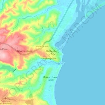
Name: Plettenberg Bay topographic map, elevation, terrain.
Location: Plettenberg Bay, George, Western Cape, 6600, South Africa (-34.09278 23.32944 -34.01278 23.40944)
Average elevation: 47 m
Minimum elevation: -3 m
Maximum elevation: 198 m
Thank you for supporting this site ❤️
Make a donation
Make a donation
Other topographic maps
Click on a map to view its topography, its elevation and its terrain.