
Kulai topographic map
Interactive map
Click on the map to display elevation.
About this map
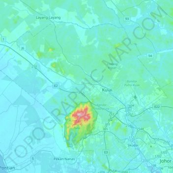
Name: Kulai topographic map, elevation, terrain.
Location: Kulai, Iskandar Malaysia, Johor, Malaysia (1.52319 103.36237 1.80539 103.73822)
Average elevation: 37 m
Minimum elevation: -1 m
Maximum elevation: 623 m
Other topographic maps
Click on a map to view its topography, its elevation and its terrain.
Pasir Gudang
Malaysia > Johor > Pasir Gudang
Pasir Gudang, Johor, 81700, Malaysia
Average elevation: 20 m