
Sandbank topographic map
Interactive map
Click on the map to display elevation.
About this map
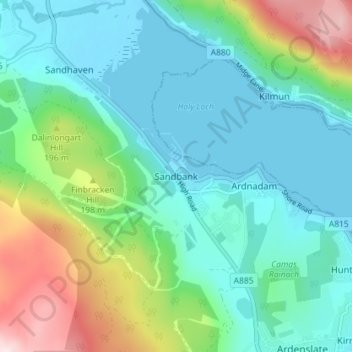
Name: Sandbank topographic map, elevation, terrain.
Location: Sandbank, Argyll and Bute, Scotland, PA23 8PJ, United Kingdom (55.96092 -4.96785 56.00092 -4.92785)
Average elevation: 100 m
Minimum elevation: -1 m
Maximum elevation: 404 m
Other topographic maps
Click on a map to view its topography, its elevation and its terrain.
Iona
United Kingdom > Scotland > Argyll and Bute > The Village
Iona, The Village, Argyll and Bute, Scotland, United Kingdom
Average elevation: 9 m
Port Bannatyne
United Kingdom > Scotland > Argyll and Bute
Port Bannatyne, Argyll and Bute, Scotland, PA20 0LW, United Kingdom
Average elevation: 52 m
Tiree
United Kingdom > Scotland > Argyll and Bute > Balevullin
Tiree, Balevullin, Argyll and Bute, Scotland, United Kingdom
Average elevation: 3 m
Colonsay
United Kingdom > Scotland > Argyll and Bute > Scalasaig
Colonsay, Scalasaig, Argyll and Bute, Scotland, United Kingdom
Average elevation: 11 m
Loch Etive
United Kingdom > Scotland > Argyll and Bute > Connel
Loch Etive, Connel, Argyll and Bute, Scotland, United Kingdom
Average elevation: 318 m
Calgary
United Kingdom > Scotland > Argyll and Bute
Calgary, Argyll and Bute, Scotland, PA75 6QU, United Kingdom
Average elevation: 109 m
Campbeltown
United Kingdom > Scotland > Argyll and Bute > Campbeltown
Campbeltown, Argyll and Bute, Scotland, PA28 6AD, United Kingdom
Average elevation: 84 m
Rothesay
United Kingdom > Scotland > Argyll and Bute
Rothesay, Argyll and Bute, Scotland, PA20 2AA, United Kingdom
Average elevation: 38 m
Staffa
United Kingdom > Scotland > Argyll and Bute
Staffa, Argyll and Bute, Scotland, United Kingdom
Average elevation: 0 m
North Connel
United Kingdom > Scotland > Argyll and Bute
North Connel, Argyll and Bute, Scotland, PA37 1PL, United Kingdom
Average elevation: 19 m