
Dempsey topographic map
Interactive map
Click on the map to display elevation.
About this map
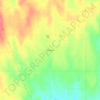
Name: Dempsey topographic map, elevation, terrain.
Location: Dempsey, Roger Mills County, Oklahoma, United States (35.49755 -99.84289 35.53755 -99.80289)
Average elevation: 733 m
Minimum elevation: 696 m
Maximum elevation: 764 m
Other topographic maps
Click on a map to view its topography, its elevation and its terrain.
Reydon
United States > Oklahoma > Roger Mills County
Reydon, Roger Mills County, Oklahoma, 73660, United States
Average elevation: 708 m
Strong City
United States > Oklahoma > Roger Mills County
Strong City, Roger Mills County, Oklahoma, United States
Average elevation: 576 m
Berlin
United States > Oklahoma > Roger Mills County
Berlin, Roger Mills County, Oklahoma, United States
Average elevation: 645 m
Carpenter
United States > Oklahoma > Roger Mills County
Carpenter, Roger Mills County, Oklahoma, United States
Average elevation: 597 m
Hammon
United States > Oklahoma > Roger Mills County
Hammon, Roger Mills County, Oklahoma, 73650, United States
Average elevation: 545 m
Cheyenne
United States > Oklahoma > Roger Mills County
Cheyenne, Roger Mills County, Oklahoma, 73628, United States
Average elevation: 610 m