Queenstown topographic map
Interactive map
Click on the map to display elevation.
About this map
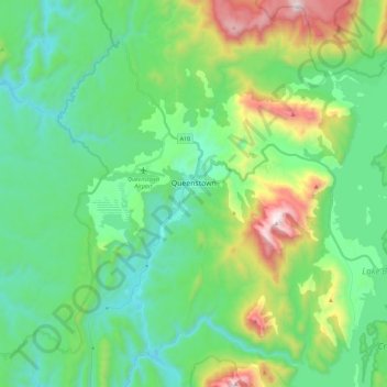
Name: Queenstown topographic map, elevation, terrain.
Location: Queenstown, West Coast, Tasmania, 7467, Australia (-42.17022 145.47523 -42.00032 145.60579)
Average elevation: 330 m
Minimum elevation: 46 m
Maximum elevation: 1,133 m
Other topographic maps
Click on a map to view its topography, its elevation and its terrain.
Modder River
Modder River, Flinders Council, Tasmania, Australia
Average elevation: 111 m
Cradle Mountain
Cradle Mountain, Kentish, Tasmania, Australia
Average elevation: 760 m
Queen River
Australia > Tasmania > Queenstown
Queen River, Queenstown, West Coast, Tasmania, Australia
Average elevation: 277 m
Port Sorell
Port Sorell, Latrobe, Tasmania, 7307, Australia
Average elevation: 16 m
Launceston
Launceston, City of Launceston, Tasmania, 7250, Australia
Average elevation: 26 m
King Island Council
King Island Council, Tasmania, Australia
Average elevation: 14 m
Central Highlands
Central Highlands, Tasmania, 7140, Australia
Average elevation: 675 m