
Borken topographic map
Interactive map
Click on the map to display elevation.
About this map
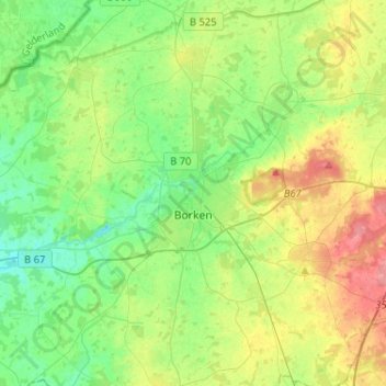
Name: Borken topographic map, elevation, terrain.
Location: Borken, Kreis Borken, Nordrhein-Westfalen, 46325, Deutschland (51.77373 6.73231 51.93287 6.92362)
Average elevation: 56 m
Minimum elevation: 31 m
Maximum elevation: 102 m
Borken gehört landschaftlich zur Westfälischen Bucht. Die Stadt, die direkt am Nordwestrand des Naturparks Hohe Mark-Westmünsterland und westlich des Höhenzugs Die Berge liegt, wird von der Borkener und Bocholter Aa durchflossen.
Other topographic maps
Click on a map to view its topography, its elevation and its terrain.
Bocholt
Deutschland > Nordrhein-Westfalen > Kreis Borken
Bocholt, Kreis Borken, Nordrhein-Westfalen, Deutschland
Average elevation: 31 m