
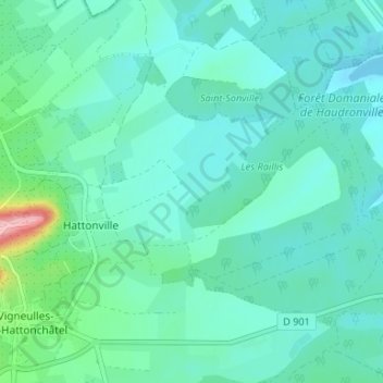
Hattonville topographic map
Interactive map
Click on the map to display elevation.
About this map
Name: Hattonville topographic map, elevation, terrain.
Average elevation: 238 m
Minimum elevation: 214 m
Maximum elevation: 357 m
Other topographic maps
Click on a map to view its topography, its elevation and its terrain.
Hattonchâtel
France > Grand Est > Meuse > Vigneulles-lès-Hattonchâtel
Hattonchâtel, Vigneulles-lès-Hattonchâtel, Commercy, Meuse, Grand Est, France métropolitaine, 55210, France
Average elevation: 327 m
Vigneulles-lès-Hattonchâtel
France > Grand Est > Meuse > Vigneulles-lès-Hattonchâtel
Vigneulles-lès-Hattonchâtel, Commercy, Meuse, Grand Est, France métropolitaine, 55210, France
Average elevation: 243 m
Cochonville
France > Grand Est > Meuse > Vigneulles-lès-Hattonchâtel
Cochonville, Vigneulles-lès-Hattonchâtel, Commercy, Meuse, Grand Est, France métropolitaine, 55210, France
Average elevation: 270 m