
Évreux topographic map
Interactive map
Click on the map to display elevation.
About this map
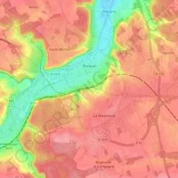
Name: Évreux topographic map, elevation, terrain.
Location: Évreux, Eure, Normandía, Francia metropolitana, 27000, Francia (48.98908 1.08938 49.04691 1.19159)
Average elevation: 119 m
Minimum elevation: 55 m
Maximum elevation: 152 m
Other topographic maps
Click on a map to view its topography, its elevation and its terrain.
La Trinité
La Trinité, Évreux, Eure, Normandía, Francia metropolitana, 27930, Francia
Average elevation: 131 m
Les Places
Les Places, Bernay, Eure, Normandía, Francia metropolitana, 27230, Francia
Average elevation: 163 m