
Agoudi N'Lkhair topographic map
Interactive map
Click on the map to display elevation.
About this map
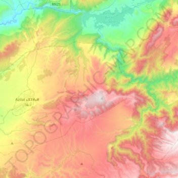
Name: Agoudi N'Lkhair topographic map, elevation, terrain.
Average elevation: 1,477 m
Minimum elevation: 656 m
Maximum elevation: 2,360 m
Other topographic maps
Click on a map to view its topography, its elevation and its terrain.
Ait Bou Oulli
Maroc > cercle d'Azilal > Aït Bou Oulli
Ait Bou Oulli, Aït Bou Oulli, caïdat de Tabant, cercle d'Azilal, Province d'Azilal, Béni Mellal-Khénifra, Maroc
Average elevation: 1,853 m
Ait Abbas
Maroc > cercle d'Azilal > Aït Abbas
Ait Abbas, Aït Abbas, caïdat d'Aït M'hamed, cercle d'Azilal, Province d'Azilal, Béni Mellal-Khénifra, Maroc
Average elevation: 1,634 m
Zaouia Ahansal
Maroc > cercle d'Azilal > Zaouiat Ahansal
Zaouia Ahansal, Zaouiat Ahansal, caïdat de Zaouïat Ahansal, cercle d'Azilal, Province d'Azilal, Béni Mellal-Khénifra, 22002, Maroc
Average elevation: 1,879 m