
Thank you for supporting this site ❤️
Make a donation
Make a donation
Foymount topographic map
Click on the map to display elevation.
Thank you for supporting this site ❤️
Make a donation
Make a donation
Foymount
The location is also popular for amateur astronomers given the high altitude and low levels of artificial light.
Thank you for supporting this site ❤️
Make a donation
Make a donation
About this map
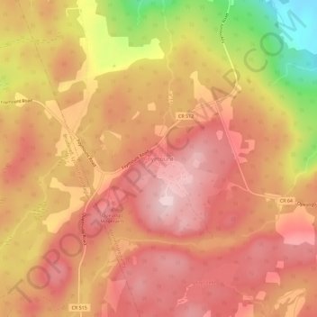
Name: Foymount topographic map, elevation, terrain.
Average elevation: 432 m
Minimum elevation: 248 m
Maximum elevation: 521 m
Thank you for supporting this site ❤️
Make a donation
Make a donation
Other topographic maps
Click on a map to view its topography, its elevation and its terrain.
Constant lake
Canada > Ontario > Renfrew County > Bonnechere Valley > Balaclava
Average elevation: 203 m
Thank you for supporting this site ❤️
Make a donation
Make a donation