
Thank you for supporting this site ❤️
Make a donation
Make a donation
Gouveia topographic map
Click on the map to display elevation.
Thank you for supporting this site ❤️
Make a donation
Make a donation
About this map
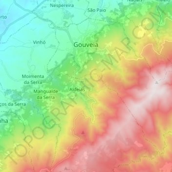
Name: Gouveia topographic map, elevation, terrain.
Location: Gouveia, Guarda, Portugal (40.43233 -7.62059 40.50898 -7.49348)
Average elevation: 902 m
Minimum elevation: 414 m
Maximum elevation: 1,593 m
Thank you for supporting this site ❤️
Make a donation
Make a donation