
Saint-Mihiel topographic map
Interactive map
Click on the map to display elevation.
About this map
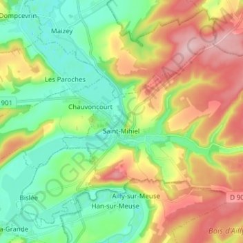
Name: Saint-Mihiel topographic map, elevation, terrain.
Average elevation: 277 m
Minimum elevation: 201 m
Maximum elevation: 395 m
Other topographic maps
Click on a map to view its topography, its elevation and its terrain.
Au-dessus de la côte Diolie
Frankreich > Grand Est > Meuse > Combres-sous-les-Côtes
Average elevation: 304 m