
Himeville Nature Reserve topographic map
Interactive map
Click on the map to display elevation.
About this map
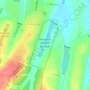
Name: Himeville Nature Reserve topographic map, elevation, terrain.
Average elevation: 1,535 m
Minimum elevation: 1,506 m
Maximum elevation: 1,581 m
Other topographic maps
Click on a map to view its topography, its elevation and its terrain.
Mzimkulu
RSA > KwaZulu-Natal > Kwa Sani Local Municipality
Mzimkulu, Kwa Sani Local Municipality, Sisonke District Municipality, KwaZulu-Natal, 3257, RSA
Average elevation: 1,841 m
Coleford Nature Reserve
RSA > KwaZulu-Natal > Kwa Sani Local Municipality
Coleford Nature Reserve, Coleford Road, Kwa Sani Ward 4, Kwa Sani Local Municipality, Sisonke District Municipality, KwaZulu-Natal, RSA
Average elevation: 1,575 m