
Bouvignes-sur-Meuse topographic map
Interactive map
Click on the map to display elevation.
About this map
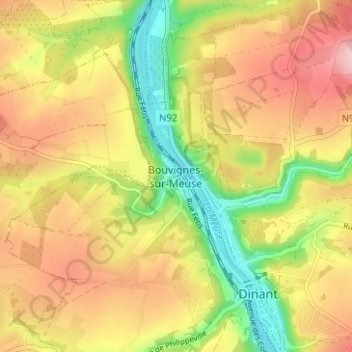
Name: Bouvignes-sur-Meuse topographic map, elevation, terrain.
Average elevation: 183 m
Minimum elevation: 83 m
Maximum elevation: 273 m
Other topographic maps
Click on a map to view its topography, its elevation and its terrain.
Foy-Notre-Dame
Belgique > Province de Namur > Dinant > Dinant
Foy-Notre-Dame, Dinant, Province de Namur, Wallonie, 5503, Belgique
Average elevation: 253 m
Lisogne
Belgique > Province de Namur > Dinant > Dinant
Lisogne, Dinant, Province de Namur, Wallonie, 5501, Belgique
Average elevation: 244 m
Anseremme
Belgique > Province de Namur > Dinant > Dinant
Anseremme, Dinant, Province de Namur, Wallonie, 5500, Belgique
Average elevation: 172 m
Neffe
Belgique > Province de Namur > Dinant > Dinant
Neffe, Dinant, Province de Namur, Wallonie, 5500, Belgique
Average elevation: 184 m
Furfooz
Belgique > Province de Namur > Dinant > Dinant
Furfooz, Dinant, Province de Namur, Wallonie, 5561, Belgique
Average elevation: 217 m