
Thank you for supporting this site ❤️
Make a donation
Make a donation
Bahía Grande topographic map
Click on the map to display elevation.
Thank you for supporting this site ❤️
Make a donation
Make a donation
About this map
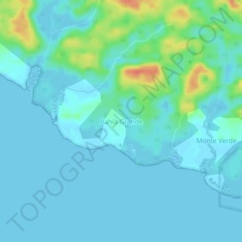
Name: Bahía Grande topographic map, elevation, terrain.
Location: Bahía Grande, Bahía Azul, Kusapín, Ngäbe-Buglé, Panamá (9.00693 -81.83941 9.04693 -81.79941)
Average elevation: 9 m
Minimum elevation: -1 m
Maximum elevation: 49 m
Thank you for supporting this site ❤️
Make a donation
Make a donation
Other topographic maps
Click on a map to view its topography, its elevation and its terrain.