
Buckingham topographic map
Interactive map
Click on the map to display elevation.
About this map
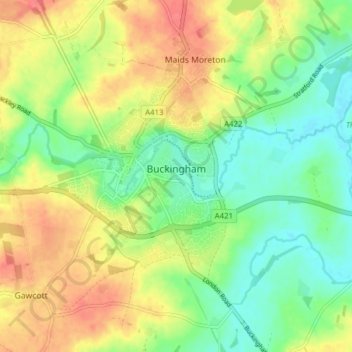
Name: Buckingham topographic map, elevation, terrain.
Average elevation: 95 m
Minimum elevation: 70 m
Maximum elevation: 127 m
Other topographic maps
Click on a map to view its topography, its elevation and its terrain.
Loudwater
Royaume-Uni > Angleterre > Buckinghamshire
Loudwater, Buckinghamshire, Angleterre, HP10 9TS, Royaume-Uni
Average elevation: 91 m
Aylesbury
Royaume-Uni > Angleterre > Buckinghamshire
Aylesbury, Buckinghamshire, Angleterre, Royaume-Uni
Average elevation: 85 m
Brill
Royaume-Uni > Angleterre > Buckinghamshire
Brill, Buckinghamshire, Angleterre, Royaume-Uni
Average elevation: 104 m
High Wycombe
Royaume-Uni > Angleterre > Buckinghamshire > High Wycombe
High Wycombe, Buckinghamshire, South East England, Angleterre, Royaume-Uni
Average elevation: 124 m
Buckland
Royaume-Uni > Angleterre > Buckinghamshire
Buckland, Buckinghamshire, Angleterre, Royaume-Uni
Average elevation: 131 m
Princes Risborough
Royaume-Uni > Angleterre > Buckinghamshire
Princes Risborough, Buckinghamshire, Angleterre, Royaume-Uni
Average elevation: 131 m
Buckinghamshire
Royaume-Uni > Angleterre > Buckinghamshire
Buckinghamshire, Grand Londres, Angleterre, Royaume-Uni
Average elevation: 103 m