
Thank you for supporting this site ❤️
Make a donation
Make a donation
La Mata topographic map
Click on the map to display elevation.
Thank you for supporting this site ❤️
Make a donation
Make a donation
About this map
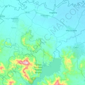
Name: La Mata topographic map, elevation, terrain.
Location: La Mata, Sánchez Ramírez, 43000, República Dominicana (18.97276 -70.28336 19.16567 -70.09973)
Average elevation: 97 m
Minimum elevation: 30 m
Maximum elevation: 557 m
Thank you for supporting this site ❤️
Make a donation
Make a donation
Other topographic maps
Click on a map to view its topography, its elevation and its terrain.