
Thank you for supporting this site ❤️
Make a donation
Make a donation
Fuerte Sherman topographic map
Click on the map to display elevation.
Thank you for supporting this site ❤️
Make a donation
Make a donation
Fuerte Sherman
Entre 1966 y 1979, se lanzaron 1.160 cohetes con una altitud máxima de vuelo de 99 kilómetros desde Fort Sherman.
Thank you for supporting this site ❤️
Make a donation
Make a donation
About this map
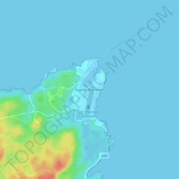
Name: Fuerte Sherman topographic map, elevation, terrain.
Location: Fuerte Sherman, Cristóbal, Colón, Panamá (9.34567 -79.97044 9.38567 -79.93044)
Average elevation: 7 m
Minimum elevation: -2 m
Maximum elevation: 62 m
Thank you for supporting this site ❤️
Make a donation
Make a donation