
Pölten topographic map
Interactive map
Click on the map to display elevation.
About this map
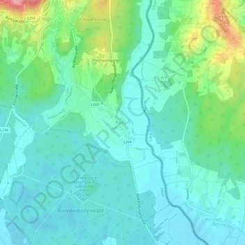
Name: Pölten topographic map, elevation, terrain.
Location: Pölten, Klöch, Bezirk Südoststeiermark, Styria, 8493, Austria (46.72390 15.96244 46.76390 16.00244)
Average elevation: 253 m
Minimum elevation: 214 m
Maximum elevation: 383 m
Other topographic maps
Click on a map to view its topography, its elevation and its terrain.
Pichla bei Radkersburg
Austria > Styria > Bezirk Südoststeiermark
Pichla bei Radkersburg, Tieschen, Bezirk Südoststeiermark, Styria, 8355, Austria
Average elevation: 307 m
Bad Radkersburg
Austria > Styria > Bezirk Südoststeiermark
Bad Radkersburg, Bezirk Südoststeiermark, Styria, 8490, Austria
Average elevation: 221 m