
Trente topographic map
Interactive map
Click on the map to display elevation.
About this map
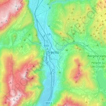
Name: Trente topographic map, elevation, terrain.
Average elevation: 786 m
Minimum elevation: 173 m
Maximum elevation: 2,137 m
Other topographic maps
Click on a map to view its topography, its elevation and its terrain.
Soraga
Italie > Trentin-Haut-Adige > Province de Trente > Soraga di Fassa
Soraga, Soraga di Fassa, Comun General de Fascia, Province de Trente, Trentin-Haut-Adige, 38035, Italie
Average elevation: 1,508 m