
Ashkelon topographic map
Interactive map
Click on the map to display elevation.
About this map
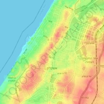
Name: Ashkelon topographic map, elevation, terrain.
Location: Ashkelon, Ashkelon Subdistrict, South District, Israel (31.64270 34.54782 31.70559 34.60656)
Average elevation: 31 m
Minimum elevation: 0 m
Maximum elevation: 69 m
Other topographic maps
Click on a map to view its topography, its elevation and its terrain.
Eilat
Eilat, Beersheba Subdistrict, South District, 8804625, Israel
Average elevation: 404 m
Sea of Galilee
Israel > South District > Bnei Shimon Regional Council
Sea of Galilee, Bnei Shimon Regional Council, South District, NO, Israel
Average elevation: -216 m