
Thank you for supporting this site ❤️
Make a donation
Make a donation
New Sharon topographic map
Click on the map to display elevation.
Thank you for supporting this site ❤️
Make a donation
Make a donation
About this map
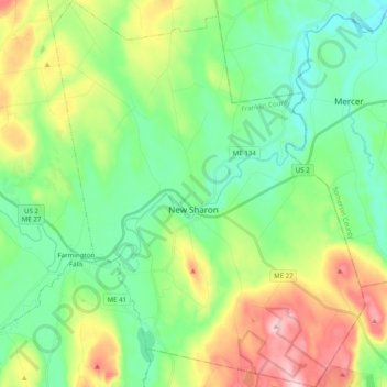
Name: New Sharon topographic map, elevation, terrain.
Location: New Sharon, Franklin County, Maine, 04955, United States (44.57464 -70.08736 44.71471 -69.92817)
Average elevation: 153 m
Minimum elevation: 53 m
Maximum elevation: 370 m
Thank you for supporting this site ❤️
Make a donation
Make a donation
Other topographic maps
Click on a map to view its topography, its elevation and its terrain.