
John Gamble Park topographic map
Interactive map
Click on the map to display elevation.
About this map
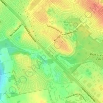
Name: John Gamble Park topographic map, elevation, terrain.
Location: John Gamble Park, Hanlon Creek, Guelph, Ontario, Canada (43.50454 -80.23384 43.50709 -80.23042)
Average elevation: 327 m
Minimum elevation: 301 m
Maximum elevation: 347 m
Other topographic maps
Click on a map to view its topography, its elevation and its terrain.
The Arboretum
The Arboretum, Guelph, Southwestern Ontario, Ontario, Canada
Average elevation: 332 m
Silver Creek Conservation Area
Silver Creek Conservation Area, The Ward, Guelph, Southwestern Ontario, Ontario, N1E 3E9, Canada
Average elevation: 326 m