
Make a donation
Cheberen topographic map
Click on the map to display elevation.
Make a donation
About this map
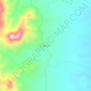
Name: Cheberen topographic map, elevation, terrain.
Location: Cheberen, Baringo, Kenya (0.21330 35.81330 0.25330 35.85330)
Average elevation: 1,600 m
Minimum elevation: 1,482 m
Maximum elevation: 1,958 m
Make a donation
Other topographic maps
Click on a map to view its topography, its elevation and its terrain.
Lake Baringo
Lake Baringo is, after Lake Turkana, the most northern of the Kenyan Rift Valley lakes, with a surface area of 130 square kilometres (50 sq mi) and an elevation of 970 metres (3,180 ft). The lake is fed by several rivers: the Molo, Perkerra and Ol Arabel. It has no obvious outlet; the waters are assumed to…
Average elevation: 1,053 m
Lake Bogoria
There are contradictions regarding its altitude. Unesco's Ramsar gives 963 m (3,159 ft). More precise — and more prudent —, Renaut & Owen 1991 give c. 990 m as of August 1977, but also indicate that the lake's level fluctuates seasonally by 50 to 100 cm; and that it can vary by several meters for short…
Average elevation: 1,318 m
Make a donation
Make a donation
Make a donation