
Nose Hill Park topographic map
Interactive map
Click on the map to display elevation.
About this map
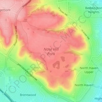
Name: Nose Hill Park topographic map, elevation, terrain.
Location: Nose Hill Park, Calgary, Alberta, T3K 2P6, Canada (51.09000 -114.13938 51.13267 -114.08322)
Average elevation: 1,174 m
Minimum elevation: 1,093 m
Maximum elevation: 1,248 m
Names currently associated with topographical features in and near Nose Hill Park reflect the impact of the European newcomers and European trade goods on the Peigan. For example, Spy Hill, the westward extension of Nose Hill, derived its present name from the aboriginal practice of communicating with distant colleagues by flashing European trade mirrors from elevated locations. Other effects of the Europeans' arrival were more insidious. The six bison that the Methodist missionaries shot during their ill-fated hunting excursion were mere remnants of southern Alberta's once vast buffalo population. By 1879, the bison herds had vanished from Nose Hill. A new chapter of local history had begun. A fledgling Euro-Canadian community, Fort Calgary, had appeared in the valley beneath Nose Hill.
Other topographic maps
Click on a map to view its topography, its elevation and its terrain.
Bearspaw Dam
Bearspaw Dam, Calgary, Mountain View, Alberta, Canada
Average elevation: 1,137 m
Glenmore Reservoir
Glenmore Reservoir, Boardwalk, Lakeview Village, Eagle Ridge, Calgary, Alberta, T3E 5L2, Canada
Average elevation: 1,085 m
Fish Creek Provincial Park
Fish Creek Provincial Park, Calgary, Alberta, Canada
Average elevation: 1,113 m
Elbow River
Elbow River, Calgary, Alberta, T3E 1H2, Canada
Average elevation: 1,100 m
Grasshopper Hill
Grasshopper Hill, Hounsfield Heights/Briar Hill, Calgary, Alberta, Canada
Average elevation: 1,076 m
Glenmore Reservoir
Glenmore Reservoir, Crowchild Trail SW, Lakeview Village, North Glenmore, Calgary, Alberta, T3E 5K4, Canada
Average elevation: 1,085 m
River Park
River Park, Altadore, Calgary, Alberta, Canada
Average elevation: 1,086 m
Edworthy Park
Edworthy Park, Wildwood, Calgary, Alberta, Canada
Average elevation: 1,129 m
Nose Creek
Nose Creek, Calgary, Alberta, T2K 6H9, Canada
Average elevation: 1,069 m
Riley Park
Riley Park, Hillhurst, Calgary, Alberta, Canada
Average elevation: 1,069 m
Dale Hodges Park
Dale Hodges Park, Montgomery, Calgary, Alberta, Canada
Average elevation: 1,092 m
Red Deer Lake
Red Deer Lake, 112 Street W, Alpine Park, Calgary, Alberta, T1S 0V8, Canada
Average elevation: 1,140 m
Barb Scott Park
Barb Scott Park, Connaught, Downtown West End, Calgary, Alberta, Canada
Average elevation: 1,061 m
Carburn Park
Carburn Park, East Fairview Industrial, Calgary, Alberta, Canada
Average elevation: 1,030 m
Ralph Klein Park
Ralph Klein Park, 12350, Shepard, Calgary, Alberta, Canada
Average elevation: 1,021 m
Bridlewood Wetlands
Bridlewood Wetlands, Somerset, Calgary, Alberta, Canada
Average elevation: 1,090 m
Sikome Lake
Sikome Lake, Sikome Circle SE, Chaparral, Calgary, Alberta, T2X3B3, Canada
Average elevation: 1,019 m