
Thank you for supporting this site ❤️
Make a donation
Make a donation
Erkensruhr topographic map
Click on the map to display elevation.
Thank you for supporting this site ❤️
Make a donation
Make a donation
About this map
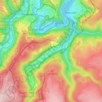
Name: Erkensruhr topographic map, elevation, terrain.
Average elevation: 430 m
Minimum elevation: 280 m
Maximum elevation: 583 m
Thank you for supporting this site ❤️
Make a donation
Make a donation
Other topographic maps
Click on a map to view its topography, its elevation and its terrain.
Rursee
Duitsland > Noordrijn-Westfalen > Stedenregio Aken > Simmerath > Woffelsbach
Average elevation: 362 m