
Ngaliema topographic map
Interactive map
Click on the map to display elevation.
About this map
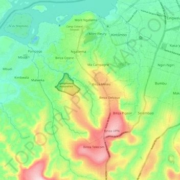
Name: Ngaliema topographic map, elevation, terrain.
Location: Ngaliema, Kinshasa, Democratic Republic of the Congo (-4.43409 15.19057 -4.31714 15.28151)
Average elevation: 341 m
Minimum elevation: 222 m
Maximum elevation: 563 m
Other topographic maps
Click on a map to view its topography, its elevation and its terrain.
Imbali
Democratic Republic of the Congo > Kinshasa > Imbali
Imbali, Masina, Tshangu, Kinshasa, Democratic Republic of the Congo
Average elevation: 283 m
Kinshasa
Democratic Republic of the Congo > Kinshasa
Kinshasa, Aketi, Kinshasa, Democratic Republic of the Congo
Average elevation: 316 m