
Vela topographic map
Interactive map
Click on the map to display elevation.
About this map
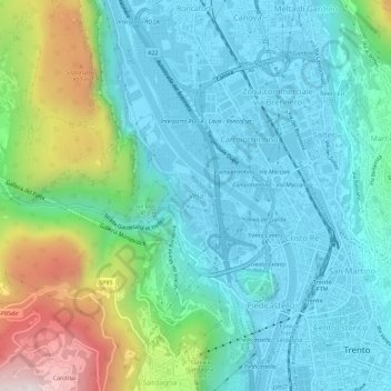
Name: Vela topographic map, elevation, terrain.
Average elevation: 391 m
Minimum elevation: 185 m
Maximum elevation: 1,062 m
Other topographic maps
Click on a map to view its topography, its elevation and its terrain.
Cortesano
Italie > Trentin-Haut-Adige > Province de Trente > Trente > Vigo Meano
Cortesano, Vigo Meano, Trente, Territorio Val d'Adige, Province de Trente, Trentin-Haut-Adige, 38015, Italie
Average elevation: 536 m