
Thank you for supporting this site ❤️
Make a donation
Make a donation
Lake St. John topographic map
Click on the map to display elevation.
Thank you for supporting this site ❤️
Make a donation
Make a donation
About this map
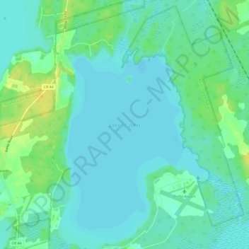
Name: Lake St. John topographic map, elevation, terrain.
Average elevation: 220 m
Minimum elevation: 213 m
Maximum elevation: 236 m
Thank you for supporting this site ❤️
Make a donation
Make a donation
Other topographic maps
Click on a map to view its topography, its elevation and its terrain.
Mara Provincial Park
Canada > Ontario > Simcoe County > Ramara Township > Atherley
Average elevation: 220 m