
Make a donation
Kaohsiung topographic map
Click on the map to display elevation.
Make a donation
About this map
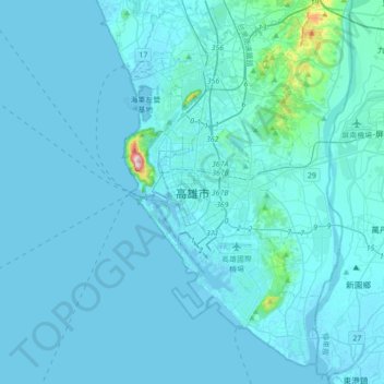
Name: Kaohsiung topographic map, elevation, terrain.
Location: Kaohsiung, Taiwan (22.46033 120.15204 22.78033 120.47204)
Average elevation: 14 m
Minimum elevation: -4 m
Maximum elevation: 339 m
Make a donation
Other topographic maps
Click on a map to view its topography, its elevation and its terrain.
Taiwan
The eastern part of the island is dominated by five mountain ranges, each running from north-northeast to south-southwest, roughly parallel to the east coast of the island. As a group, they extend 330 km (210 mi) from north to south and average about 80 kilometres (50 mi) from east to west. They include more…
Average elevation: 196 m
Make a donation
Make a donation
Yangmingshan National Park
Unlike most other national parks, the Yangmingshan National Park has a lower elevation. Although the park's elevation ranges from only 200–1120 meters, varied landscapes such as ridges, valleys, lakes, waterfalls, and basins are abundant. Andesite rocks make up most of the area's geology.
Average elevation: 397 m
Alishan Township
It has a population total of 5,374 and an area of 427.8471 square kilometres. It is located at an elevation of 2,190 metres (7,190 ft) in the western highlands of Taiwan.
Average elevation: 1,645 m
Make a donation
Make a donation
Make a donation
Make a donation
Alishan Township
It has a population total of 5,374 and an area of 427.8471 square kilometres. It is located at an elevation of 2,190 metres (7,190 ft) in the western highlands of Taiwan.
Average elevation: 1,645 m
Make a donation
Make a donation
Make a donation
Make a donation
Yuanlin City
Yuanlin has a station on the Taiwan Railways Administration's Western Line. A project is underway to redevelop the station in combination with converting the current at-grade line to an elevated line through the city, a plan designed to improve road traffic flow and promote investment. The elevation of the…
Average elevation: 52 m
Make a donation
Make a donation
Yuanlin City
Yuanlin has a station on the Taiwan Railway's Western Line. A project is underway to redevelop the station in combination with converting the current at-grade line to an elevated line through the city, a plan designed to improve road traffic flow and promote investment. The elevation of the track will…
Average elevation: 52 m
Make a donation
Make a donation
Make a donation
Alishan Township
It has a population total of 5,374 and an area of 427.8471 square kilometres. It is located at an elevation of 2,190 metres (7,190 ft) in the western highlands of Taiwan.
Average elevation: 1,645 m
Make a donation
Jiaming Lake
Taiwan > Taitung County > Haiduan
This oval-shaped lake is located along the Southern Cross-Island Highway. The lake surface is 120 meters long and 80 meters wide at an elevation of 3,310 meters. It is surrounded by emerald green forest plantation and wildlife. The area surrounds the lake has lodges and hiking trail with a length of 13 km.
Average elevation: 3,191 m
Make a donation
Make a donation
Make a donation
Make a donation
Make a donation
Yilan City
Yilan City is located on Lanyang Plain with an average altitude of 7.38 meters above sea level.
Average elevation: 10 m
Make a donation
Make a donation
Make a donation