
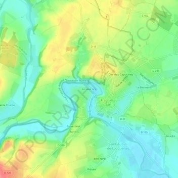
Le Haut Ary topographic map
Interactive map
Click on the map to display elevation.
About this map
Name: Le Haut Ary topographic map, elevation, terrain.
Average elevation: 96 m
Minimum elevation: 68 m
Maximum elevation: 139 m
Other topographic maps
Click on a map to view its topography, its elevation and its terrain.
Saint-Germain-sur-Sarthe
France > Pays de la Loire > Sarthe > Fresnay-sur-Sarthe
Saint-Germain-sur-Sarthe, Fresnay-sur-Sarthe, Mamers, Sarthe, Pays de la Loire, France métropolitaine, 72130, France
Average elevation: 82 m
Fresnay-sur-Sarthe
France > Pays de la Loire > Sarthe > Fresnay-sur-Sarthe
Fresnay-sur-Sarthe, Mamers, Sarthe, Pays de la Loire, France métropolitaine, 72130, France
Average elevation: 95 m
Coulombiers
France > Pays de la Loire > Sarthe > Fresnay-sur-Sarthe
Coulombiers, Fresnay-sur-Sarthe, Mamers, Sarthe, Pays de la Loire, France métropolitaine, 72130, France
Average elevation: 91 m