
Thank you for supporting this site ❤️
Make a donation
Make a donation
Shah Alam topographic map
Click on the map to display elevation.
Thank you for supporting this site ❤️
Make a donation
Make a donation
Shah Alam
Located in Klang Valley, Shah Alam topography is mostly flat, except in the northern part of the city where it features a prominent rolling hill.
Thank you for supporting this site ❤️
Make a donation
Make a donation
About this map
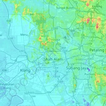
Name: Shah Alam topographic map, elevation, terrain.
Location: Shah Alam, Petaling, Selangor, Malaysia (2.94962 101.42773 3.22972 101.59139)
Average elevation: 28 m
Minimum elevation: -42 m
Maximum elevation: 324 m
Thank you for supporting this site ❤️
Make a donation
Make a donation
Other topographic maps
Click on a map to view its topography, its elevation and its terrain.
Hulu Kelang
Malaysia > Selangor > Ampang Jaya Municipal Council > Hulu Kelang
Average elevation: 147 m
Thank you for supporting this site ❤️
Make a donation
Make a donation