
Thank you for supporting this site ❤️
Make a donation
Make a donation
Piedades Sur topographic map
Click on the map to display elevation.
Thank you for supporting this site ❤️
Make a donation
Make a donation
About this map
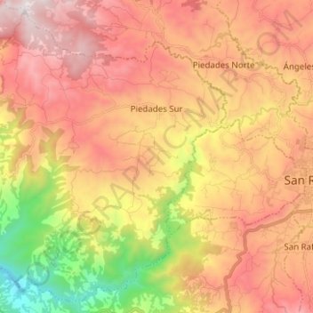
Name: Piedades Sur topographic map, elevation, terrain.
Location: Piedades Sur, San Ramón, Alajuela, 20205, Costa Rica (10.04071 -84.63126 10.15431 -84.50649)
Average elevation: 985 m
Minimum elevation: 218 m
Maximum elevation: 1,596 m
Thank you for supporting this site ❤️
Make a donation
Make a donation
Other topographic maps
Click on a map to view its topography, its elevation and its terrain.