
Thank you for supporting this site ❤️
Make a donation
Make a donation
Stützerbach topographic map
Click on the map to display elevation.
Thank you for supporting this site ❤️
Make a donation
Make a donation
About this map
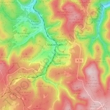
Name: Stützerbach topographic map, elevation, terrain.
Location: Stützerbach, Ilmenau, Ilm-Kreis, Thuringia, Germany (50.61114 10.82529 50.65171 10.89765)
Average elevation: 705 m
Minimum elevation: 546 m
Maximum elevation: 830 m
Thank you for supporting this site ❤️
Make a donation
Make a donation
Other topographic maps
Click on a map to view its topography, its elevation and its terrain.