
Gernrode topographic map
Interactive map
Click on the map to display elevation.
About this map
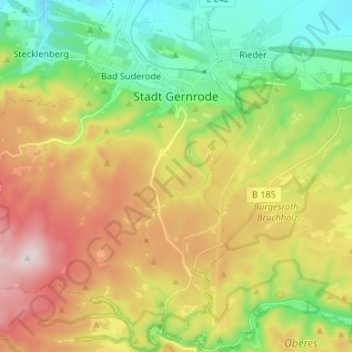
Name: Gernrode topographic map, elevation, terrain.
Average elevation: 331 m
Minimum elevation: 151 m
Maximum elevation: 583 m
Other topographic maps
Click on a map to view its topography, its elevation and its terrain.
Hagental
Duitsland > Saksen-Anhalt > Gernrode > Haferfeld
Hagental, Haferfeld, Gernrode, Quedlinburg, Landkreis Harz, Saksen-Anhalt, 06485, Duitsland
Average elevation: 361 m