
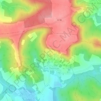
Saint-Thomas topographic map
Interactive map
Click on the map to display elevation.
About this map
Name: Saint-Thomas topographic map, elevation, terrain.
Average elevation: 148 m
Minimum elevation: 87 m
Maximum elevation: 216 m
Other topographic maps
Click on a map to view its topography, its elevation and its terrain.
Montbrehain
France > Hauts-de-France > Aisne
Montbrehain, Saint-Quentin, Aisne, Hauts-de-France, Metropolitan France, 02110, France
Average elevation: 137 m
Castres
France > Hauts-de-France > Aisne
Castres, Saint-Quentin, Aisne, Hauts-de-France, Metropolitan France, 02680, France
Average elevation: 85 m
Gandelu
France > Hauts-de-France > Aisne
Gandelu, Château-Thierry, Aisne, Hauts-de-France, Metropolitan France, 02810, France
Average elevation: 121 m